


Information for residents
This page provides additional information regarding the upcoming drone inspection or survey in your area, as mentioned in our recent notification letter.
Questions & Answers
Why did you receive a letter from us?
If you received a letter from us, it means a client has recently asked us to carry out surveying measurements or an inspection in the area you are living in or if your business is located here. Our clients are often municipalities, provinces, contractors, engineering firms, and housing corporations. We are obligated to inform residents surrounding a radius of 50 meters in and around the flight area.
What does Eyefly do?
Eyefly specializes in drone surveying, drone inspections, and processing 3D data. Our projects combine aerial, water-based, and ground photography with techniques such as LiDAR (laser scanning), various sensors, AI (artificial intelligence), and traditional surveying methods. We primarily deliver highly detailed, high-quality, reliable, and future-proof data for data processing, for 3D models and even game engines.
With our advanced drones, 100-megapixel cameras and smart software, we work efficiently on projects throughout the Netherlands and occasionally beyond. We measure and inspect at the highest level!
If you would like to learn more about our projects, please watch our overview video (in Dutch) below:
What is a drone?
A drone is an unmanned aviation craft that is remotely controlled by a drone pilot. Eyefly operates exclusively with the highest-quality, professional drones and equipment. Our 100-megapixel cameras can zoom in with an accuracy of up to 0.5 millimeters. Even the smallest details are clearly visible.
Would you like to learn more about the drones we use? Please visit our drone web page here.
Is Eyefly permitted to fly?
Yes, we are allowed to fly in almost all airspace in the Netherlands. We posses a so-called OA (Operational Authorization), which is issued by the Dutch ILT (Human Environment and Transport Inspectorate). This OA is a permit granted by the Dutch government to us as a drone operator to perform commercial drone flights. We always have our permit with us.
Within this authorization, additional permits are included. For example, we are allowed to fly over residential areas, railway lines, or within the no-fly zones of Dutch airports (both military and civil).
Learn more about our certifications here.
How is my privacy protected?
It may occur that the drone flies near you or your home during a survey or inspection. We emphasize that our focus is not on your personal property or any other sensitive information. For data processing, only images relevant to the project are used, and only surveying information is processed.
If any images contain visible property or personal data, these images will be removed or made unrecognizable by applying “blurring.”
What is blurring and how does it work?
Images with personal data visible are blurred automatically by our AI software, ensuring that faces and license plates are no longer recognizable. The images below show how automatic blurring is applied.


How are drone flights performed safely?
Our operational manual describes procedures for conducting drone flights safely. These procedures have been reviewed by the Dutch ILT (Human Environment and Transport Inspectorate) and based on this review, our permit has been issued.
During operations, we always wear recognizable orange safety vests with our company name (Eyefly) and logo. Our flights are always carried out by a team of at least two people: one person is the drone pilot which is responsible for flying the drone. The second person is the observer which is responsible for monitoring the airspace and surroundings and can answer questions from bystanders. In some cases, we operate with three people, for example near controlled airspaces. In these situations, the third person maintains in direct contact with air traffic control.
In addition to operational procedures and working methods, our latest drones are equipped with extra sensors such as LiDAR (laser scanning). LiDAR is used for more accurate positioning and for detecting obstacles so that we can avoid collisions.
A crash can always occur and never be prevented for 100 percent. But with our procedures and the technical features of the drones, the risk is significantly reduced. We do advise residents not to walk underneath our drones.
What happens to the images?
Drones are used for a wide range of purposes. The collected drone images usually are processed into 3D products, used for inspections and surveying measurements. Our intention is to never collect data with personal information.
Only the data relevant to the assignment is shared with our client. The client determines how long the images are used and when they are archived. Images are not shared with third parties or unauthorized persons unless this is necessary for carrying out an assignment.
If your question is not listed here or if you have any comments, please contact us here.


Actueel
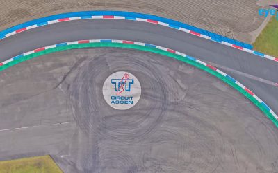
TT Circuit Assen in hoge resolutie
In samenwerking met Geomaat hebben wij het iconische TT Circuit in Assen volledig en zeer nauwkeurig vastgelegd. Over het TT Circuit Assen Het TT Circuit in Assen, ook wel bekend als The Cathedral...

Van inwinning tot inzicht: natuurgebied De Kreupel
Rijkswaterstaat is bronhouder geworden van natuurgebied De Kreupel in Midden-Nederland. Voor goed beheer is een betrouwbare basiskaart nodig. Van meting tot basiskaart In samenwerking met...
Vacature Commercieel Medewerker / Accountmanager
Eyefly zoekt een Commercieel Medewerker / Accountmanager. Ben jij onze commerciële motor die kansen ziet, deuren opent en meedenkt over hoe wij onze drone-diensten verder laten groeien? Lees dan...
Meer informatie over onze diensten en werkzaamheden?
Vraag naar de mogelijkheden bij een van onze specialisten of neem contact met ons op door een bericht te sturen.